![]()
In the wake of historic flooding in Texas, the 2019 Texas Legislature passed legislation to create Texas’ first-ever regional and state flood planning process. The Legislature created a state flood planning framework and charged the Texas Water Development Board (TWDB) with creating flood planning regions based on river basins and with administering the ongoing work of flood planning.
The San Jacinto Regional Flood Planning Group (San Jacinto Region) is one of the 15 Regional Flood Planning Groups (RFPGs) formed by the TWDB. San Jacinto Region includes all or part of 11 counties and extends from Galveston in the south to Huntsville in the north.
Through this groundbreaking, first of its kind flood planning effort, San Jacinto Region received a flood planning grant from the TWDB to help identify specific flood risks as well as strategies to reduce flood risks in coming years. This effort represents a bottom-up approach to flood planning and is intended to be a transparent process which relies on public input.
Visit the TWDB website for more information.
The San Jacinto region spans all or parts of 11 counties, stretching from Galveston County on the coast to Walker County in the north. Covering 5,089 square miles, it is the second smallest flood planning region in Texas by area but the second most populous, home to approximately 6.4 million people. With 1,200 people per square mile, it is also the state’s most densely populated region.
The region features diverse landscapes — from coastal areas below sea level to elevations of about 400 feet in northern Walker County — and is served by an extensive network of natural and built flood infrastructure. This includes roughly 3,700 miles of streams, creeks, and bayous, as well as thousands of acres of ponds, reservoirs, and wetlands.
Flooding is a major concern due to the region’s development and coastal proximity. From 1975 to 2019, the San Jacinto region recorded the highest number of National Flood Insurance Program (NFIP) claims in Texas. About 21% of the state’s population lives here, requiring a balance between the needs of rural communities and rapidly growing urban centers, particularly in the Greater Houston area and along the coast. The region includes 92 municipalities, with most residents concentrated in and around Houston.
*Indicates this county is partially within this RFPG and is also represented by at least one other RFPG.
*Indicates this city is partially within this RFPG and is also represented by at least one other RFPG.
The TWDB’s regional flood planning process was developed, and initial regional flood planning groups were formed in mid-2020. This planning process will be ongoing, and an updated plan will be developed by the TWDB every five years.
The first regional flood plans were submitted in July 2023, and the first state flood plan was submitted to the Texas Legislature in September 2024.
See the TWDB State Flood Plan Page here.
Now, the flood planning regions are beginning the second planning cycle. The second San Jacinto Regional Flood Plan is due to the TWDB by January 10, 2028, and will be incorporated into the overall 2029 State Flood Plan.
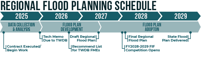
Key tasks the San Jacinto RFPG has planned to accomplish during the second regional flood planning cycle include:
The 2023 San Jacinto Regional Flood Plan outlines several critical recommendations to address flood risks in the region. These recommendations include:
Through collaboration with local communities, the plan identifies 70 recommended flood mitigation projects, 65 management strategies, and 405 evaluations. If implemented, the recommended flood mitigation actions would have a positive impact on flood preparedness and flood risk reduction, including helping to address flood data gaps and identifying high flood risk areas and will result in the identification of future flood mitigation projects. The total cost of the recommended actions is estimated at $33.8 billion, with funding expected from a combination of local, state, and federal sources.
The 2023 Regional Flood Plan marks a significant step forward in protecting Region 6 from the devastating effects of future floods. With ongoing public engagement and future updates to the plan, Region 6 will continue to refine its strategies and strengthen its flood resilience. The first San Jacinto Regional Flood Plan was officially submitted to the Texas Water Development Board in July 2023.
Learn more about the 2023 San Jacinto Regional Flood Plan here.
Learn more about the 2024 State Flood Plan here.
The San Jacinto RFPG consists of 16 voting members and 14 non-voting members, selected through a nomination process. These members represent a wide range of sectors, including:
Executive Committee
Technical Committee
Outreach Committee
The success of the San Jacinto RFPG depends on input from the public. By engaging with local communities, the group ensures that the flood planning process is transparent and that it reflects the priorities and concerns of those most affected by flooding. A key component of the regional flood planning process is identifying community funding needs for the implementation of flood risk management and mitigation measures. Only items included in the plan will be eligible for state funding through the TWDB.
If you are interested in learning more about the flood planning process or want to get involved, there are several ways to connect with the us: